
Page 44 - TINA Dergi Sayi 10
P. 44
TINA
Denizcilik Arkeolojisi Dergisi
Yerleşme konumuna ve büyüklüğüne göre en uy- It is important to choose the most suitable survey
gun yüzey araştırması yöntemlerinin ve tekniklerinin methods and technologies to be used according to the
seçilmesi önemlidir, yani imar nedeniyle tahrip ol- nature and size of the site locality, e.g. different meth-
mak üzere olan yerleşmelerin kurtarma kazısı ve bel- ods are needed for rescue excavation and documenta-
gelenmesi için tehdit altında olmayan sualtında kalan tion of sites faced with immediate destructive develop-
yerleşmelerin uzun zamana yayılan araştırmalarına ment, versus long term investigation of unthreatened
göre farklı yöntemler gereklidir. Son birkaç on yılda submerged sites.
uzaktan algılama sistemi ve sualtı fotoğrafçılığı gibi In recent decades, methods such as remote sensing
yöntemlerde önemli gelişmeler sağlanmıştır. Aynı and underwater photography have undergone consider-
şekilde çok katmanlı ve poligon haritalama, 3 boyut- able development. Also, the development of computer
lu modellerin oluşturulabilmesi, CBS kullanılarak programs that enable multi-layer and polygon mapping,
geçmişe yönelik arazi rekonstrüksiyonu gibi teknik- creation of 3D models and past landscape reconstruc-
lerin tümü deniz dibindeki prehistorik yerleşmelerin tions using GIS, all aid in reconstructing prehistoric
ve alanların yeniden kurulmasına katkıları olmuştur. settlements, landscapes and sites on the sea bottom. Our
Geliştirdiğimiz araştırma modeli aynı işin sıklıkla research model recommends choosing the most suitable
basit, kolayca bulunabilen, düşük maliyetli ekipman- technology for the job, bearing in mind that often the
ların kullanılmasıyla yapılabileceğini göz önünde same work can be successfully undertaken using sim-
bulundurarak işe en uygun teknolojinin seçilmesini ple, readily available, low cost equipment .
35
önermektedir . The Israeli model of submerged prehistoric investiga-
35
Su altında kalmış yerleşmelerin konumlandırılmasını tion proposes a general, multi-disciplinary investigation
hedefleyen İsrail prehistorik batık araştırma modeli, aimed at locating submerged sites for the purpose of
haritalama, izleme, kontrol ve kurtarma amacıyla ge- mapping, researching, monitoring, managing and res-
nel, çok disiplinli bir araştırma önermektedir. Bu aşa- cuing. These stages are listed below, stressing that since
malar aşağıda sıralanmıştır, yerleşmeler birbirlerinden the sites differ, not all actions are needed in each site:
farklı olduğundan her yerleşme için aynı eylemlerin 1. Collection of Information: Available information
gerekmediğini vurgulamakta fayda var: associated with the study area should be collected
1. Bilgi Toplanması: Çalışma alanıyla ilgili bilgi- from mariners, marine industries, fisherman and
ler denizciler, deniz sanayileri, balıkçılar ve amatör amateur divers, as well as the collection of existing
dalgıçların yanısıra mevcut toplanmış verilerden elde data. This includes gathering oral and written infor-
edilmelidir. Bunlar ağızdan ve yazılı bilgi toplanma- mation, searching publications, topographic, bathy-
sının yanısıra yayın taraması, topografik, batimetrik, metric, geological and lithological maps, as well as
jeolojik ve litolojik haritalarda arama yapılması, aynı taking into account the nature and location of known
zamanda bilinen karadaki ve su altında kalmış arke- archaeological sites on land and those that are sub-
olojik alanların özellikleri ve konumlarının dikkate merged.
alınmasını içermektedir.
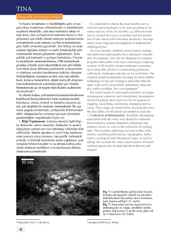
Fig. 7: Carmel Burnu açıklarındaki kayalık
levhada antropojenik kökenli taş kümeleri.
(kabuklu deniz hayvanları/ deniz kestanesi,
balık üretme çiftliği?) (E. Galili)
Fig. 7: Stone piles that are suspected to be
anthropogenic in origin. (shellfish/ urchin
garden, fish nursery?) on the rocky plate off
the Carmel nose (E. Galili)
35 Ayrıca bkz. GALILI vd. 2017d. 35 see also GALILI et al. 2017d.
42