
Page 40 - TINA Dergi Sayi 10
P. 40
TINA
Denizcilik Arkeolojisi Dergisi
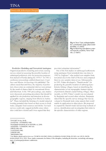
Fig. 6: Neve Yam yerleşmesinden
kıyı yakınlarında açığa çıkan konut
temelleri. (J. Galili)
Fig. 6: Dwelling foundations expo-
sed near the coastline, Neve-Yam
site. (J. Galili)
Predictive Modeling and Terrestrial Analogues: provided redundant information .
22
Organized predictive modeling and remote sensing One of the first studies on submerged settlements
surveys aimed at assessing the possible location of using analogues from terrestrial sites was done in
submerged prehistoric sites for protection purposes, 1982 by Gagliano who studied core samples from
23
first started in Florida during the 1970’s . In 1983 a terrestrial sites in the Gulf of Mexico and compared
18
conference proceedings entitled Quaternary Coast- them to core samples taken at sea. Subsequently,
lines and Marine Archaeology was published. The in 1995, Fisher developed a “Danish model” for
editors noted that until then, the majority of prehis- predicting the possible location of submerged pre-
toric discoveries on continental shelves were primar- historic fishing villages, based on identifying the
ily the result of chance finds by recreational divers characteristics of six topographic features typical
and fishermen. In the 1983 proceedings, case studies of prehistoric Danish coastal fishing villages. More
were discussed, presenting procedures that should be recently, in 2010, Fisher’s model was reevaluated
applied for site prediction and detection in diverse by Benjamin and several other scholars. Benjamin
geographic regions, ranging from Siberia to Austra- stated that the specific survey strategy that was de-
lia . These included the forming of a model aimed at veloped in Denmark lacks some aspects that would
20
locating potential sites based on their access to fresh enable its application in other places. He proposed
water, adequate food resources and shelter. Yet such to expand the Danish model and develop methods of
surveys could only suggest probable areas where survey, identification and investigation that relate to
sites could have existed and it was argued that they the specific characteristics of other regions.
18 FAUGHT 2014a, 2014b.
19 MASTERS – FLEMMING 1983.
20 FLATMAN-EVANCE 2014; ULDUM et al. 2018.
21 MASTERS - FLEMMING 1983: 624.
22 PRICE 1995: 424.
23 GAGLIANO 1982.
24 FISHER 1995.
25 BENJAMIN 2010.
26 For further details and reviews see: GUSICK-FAUGHT (2010), FLATMAN-EVANS (2014), STURT et al. (2018), WICK-
HAM-JONES 2010, 2018. These studies summarize the history of the discipline, including the detection, researching and manage-
ment of submerged prehistoric settlements.
38