
Page 46 - TINA Dergi Sayi 10
P. 46
TINA
Denizcilik Arkeolojisi Dergisi
Batimetriyi, kumların altındaki fosil toprakları The survey yielded maps depicting the ba-
(paleotopografiyi temsil ediyor), fosil toprakların al- thymetry, the surface of the palaeosol below the
tındaki kurkar kayanın yüzeyi, kum dolgulu izopakları sand (representing the palaeotopography), the
(kum kalınlığını temsil ediyor) ve fosil toprak izo- surface of the kurkar rock under the palaeosol,
pakları (fosil toprak kalınlığını temsil ediyor) ve di- sand fill isopachs (representing the thickness of
paltının profillerini betimleyen haritalar araştırmanın the sand) and palaeosol isopachs (representing
37
39
ürünüdür . Adler ve Galili yüksek lisans araştır- the sickness of the palaeosol) and profiles of the
38
37
malarının bir parçası olarak Carmel kıyısında (kıyı sub-bottom . As part of their MA research, both
38
39
şeridinin batısında bulunan kıyının açıklarındaki batık Adler and Galili undertook two sets of water
kurkar sırtı) iki basınçlı su sondajı (su jeti ile sondaj) probes (jet drillings) across the northern Carmel
yapmayı üstlendiler. 50 m aralıklarla işaretlenen 850 coast (from the coastline to the submerged off-
m uzunluğunda bir tel denizin dibine yerleştirildi. shore kurkar ridge to the west). A metal line, 850
m long, tagged every 50 m, was placed on the
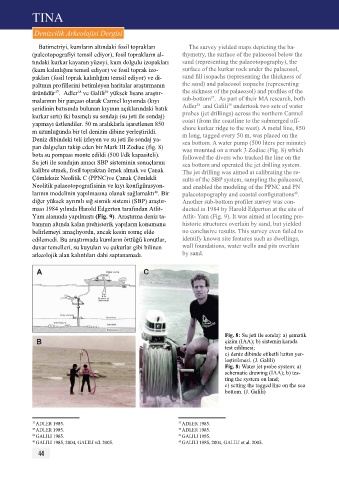
Deniz dibindeki teli izleyen ve su jeti ile sondaj ya- sea bottom. A water pump (500 liters per minute)
pan dalgıçları takip eden bir Mark III Zodiac (fig. 8) was mounted on a mark 3 Zodiac (Fig. 8) which
bota su pompası monte edildi (500 l/dk kapasiteli). followed the divers who tracked the line on the
Su jeti ile sondajın amacı SBp sisteminin sonuçlarını sea bottom and operated the jet drilling system.
kalibre etmek, fosil topraktan örnek almak ve Çanak The jet drilling was aimed at calibrating the re-
Çömleksiz Neolitik C (ppNC)ve Çanak Çömlekli sults of the SBP system, sampling the palaeosol,
Neolitik palaeotopografisinin ve kıyı konfigürasyon- and enabled the modeling of the PPNC and PN
larının modelinin yapılmasına olanak sağlamaktı . Bir palaeotopography and coastal configurations .
40
40
diğer yüksek ayrımlı sığ sismik sistemi (SBp) araştır- Another sub-bottom profiler survey was con-
ması 1984 yılında Harold Edgerton tarafından Atlit- ducted in 1984 by Harold Edgerton at the site of
Yam alanında yapılmıştı (Fig. 9). Araştırma deniz ta- Atlit- Yam (Fig. 9). It was aimed at locating pre-
banının altında kalan prehistorik yapıların konumunu historic structures overlain by sand, but yielded
belirlemeyi amaçlıyordu, ancak kesin sonuç elde no conclusive results. This survey even failed to
edilemedi. Bu araştırmada kumların örttüğü konutlar, identify known site features such as dwellings,
duvar temelleri, su kuyuları ve çukurlar gibi bilinen wall foundations, water wells and pits overlain
arkeolojik alan kalıntıları dahi saptanamadı. by sand.
Fig. 8: Su jeti ile sondaj: a) şematik
çizim (IAA); b) sistemin karada
test edilmesi;
c) deniz dibinde etiketli hattın yer-
leştirilmesi. (J. Galili)
Fig. 8: Water jet probe system: a)
schematic drawing (IAA); b) tes-
ting the system on land;
c) setting the tagged line on the sea
bottom. (J. Galili)
37 ADLER 1985. 37 ADLER 1985.
38 ADLER 1985. 38 ADLER 1985.
39 GALILI 1985. 39 GALILI 1985.
40 GALILI 1985, 2004, GALILI vd. 2005. 40 GALILI 1985, 2004, GALILI et al. 2005.
44