
Page 59 - TINA Dergi Sayi 11
P. 59
TINA
Maritime Archaeology Periodical
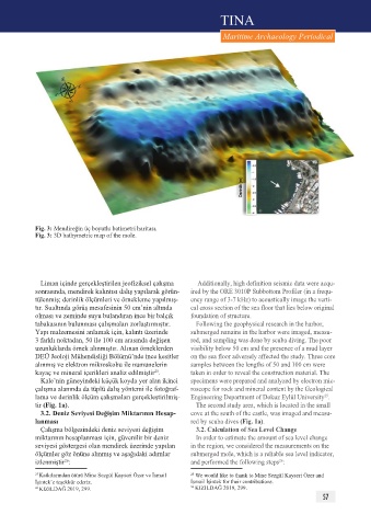
Fig. 3: Mendireğin üç boyutlu batimetri haritası.
Fig. 3: 3D bathymetric map of the mole.
Liman içinde gerçekleştirilen jeofiziksel çalışma Additionally, high definition seismic data were acqu-
sonrasında, mendirek kalıntısı dalış yapılarak görün- ired by the ORE 3010P Subbottom Profiler (in a frequ-
tülenmiş; derinlik ölçümleri ve örnekleme yapılmış- ency range of 3-7 kHz) to acoustically image the verti-
tır. Sualtında görüş mesafesinin 50 cm’nin altında cal cross section of the sea floor that lies below original
olması ve zeminde suyu bulandıran ince bir balçık foundation of structure.
tabakasının bulunması çalışmaları zorlaştırmıştır. Following the geophysical research in the harbor,
Yapı malzemesini anlamak için, kalıntı üzerinde submerged remains in the harbor were imaged, measu-
3 farklı noktadan, 50 ile 100 cm arasında değişen red, and sampling was done by scuba diving. The poor
uzunluklarda örnek alınmıştır. Alınan örneklerden visibility below 50 cm and the presence of a mud layer
DEÜ Jeoloji Mühendisliği Bölümü’nde ince kesitler on the sea floor adversely affected the study. Three core
alınmış ve elektron mikroskobu ile numunelerin samples between the lengths of 50 and 100 cm were
25
kayaç ve mineral içerikleri analiz edilmiştir . taken in order to reveal the construction material. The
Kale’nin güneyindeki küçük koyda yer alan ikinci specimens were prepared and analyzed by electron mic-
çalışma alanında da tüplü dalış yöntemi ile fotoğraf- roscope for rock and mineral content by the Geological
25
lama ve derinlik ölçüm çalışmaları gerçekleştirilmiş- Engineering Department of Dokuz Eylül University .
tir (Fig. 1a). The second study area, which is located in the small
3.2. Deniz Seviyesi Değişim Miktarının Hesap- cove at the south of the castle, was imaged and measu-
lanması red by scuba dives (Fig. 1a).
Çalışma bölgesindeki deniz seviyesi değişim 3.2. Calculation of Sea Level Change
miktarının hesaplanması için, güvenilir bir deniz In order to estimate the amount of sea level change
seviyesi göstergesi olan mendirek üzerinde yapılan in the region, we considered the measurements on the
ölçümler göz önüne alınmış ve aşağıdaki adımlar submerged mole, which is a reliable sea level indicator,
26
izlenmiştir : and performed the following steps :
26
25 Katkılarından ötürü Mine Sezgül Kayseri Özer ve İsmail 25 We would like to thank to Mine Sezgül Kayseri Özer and
İşintek’e teşekkür ederiz. İsmail İşintek for their contributions.
26 KIZILDAĞ 2019, 299. 26 KIZILDAĞ 2019, 299.
57