
Page 57 - TINA Dergi Sayi 11
P. 57
TINA
Maritime Archaeology Periodical
Newton, 1862’de çizdiği haritasında, gizli limanı, In the map he drew in 1862, Newton separated the
17
çalışma konusu mendirek ile büyük limandan ayır- secret harbor from the main harbor by a mole .
17
maktadır . Vitruvius (II.8.11,13-14) anlatımında Vitruvius (II.8.11,13-14) mentioned a “small har-
büyük “ticari liman” ve “gizli liman”ın dışında “küçük bor” in addition to the large “commercial harbor” and
18
liman”dan söz etmektedir . Spratt (Fig.1c) ve New- the “secret harbor. ” Furthermore, Spratt (Fig.1c) and
18
ton’un haritalarında ayrıca Halikarnassos limanının Newton mapped two large submerged breakwaters
girişinde her iki yanda sualtında kalmış büyük dalga- on both sides of the entrance of Halicarnassus harbor.
kıranlar görülmektedir. 20.yy.da bu yapılar üzerine Modern breakwaters were built above them in the 20
th
modern dalgakıranlar inşa edilmiştir. century.
Önceki çalışmalarda, kalenin güneyindeki küçük In previous studies, a submerged rock-cut structure,
koyda, ana kayanın kesilmesiyle açığa doğru derinle- which continues further down into the sea, was identi-
şen bir yapı tespit edilmiş ve çekek yeri olarak değer- fied in the small cove to the south of the castle .
19
lendirilerek bu koyun gizli liman olabileceği şeklinde
19
yorum yapılmıştır .
17 PEDERSEN 1994, 224, Fig.1 17 PEDERSEN 1994, 224, Fig.1
18 Burada geçen “gizli liman” ile “küçük liman”ın aynı olabileceği 18 “Secret harbor” and “small harbor” are probably the same place.
ihtimali bulunmaktadır. 19 We performed a short underwater survey on the northern coast
19 2005 yılında Paul Pedersen ile birlikte kalenin güneyinde yaptığı- of castle with Paul Pedersen in 2005 and the submerged structure
mız kısa süreli bir sualtı araştırmasında söz konusu yapı belgelen- was documented as a part of this work. This area was probably
miştir. Mausolos’un saltanat veya özel savaş gemileri için bir bölge for Mausolus’ battle ships, which was interpreted by Pedersen as a
olması ihtimali bulunmakta olup, Pedersen burayı çekek yeri veya shipshed or a secret harbor (2010, 276, Fig.1). Baika (2013, 204,
gizli liman olarak tanımlamıştır (2010, 276, Fig.1). Baika (2013, 204, Fig.A10.11) also mentioned this structure and suggested that in
Fig.A10.11) çalışmasında bu yapıya yer vermiştir. Baika’ya göre democratic city-states, shipsheds and naval arsenals were related
(2013, 203), demokratik şehir devletlerinde çekek yerleri ve deniz to fortified command-posts or an acropolis. According to Baika
cephaneliği, güçlü komuta merkezleriyle veya yakındaki akropollerle (2013, 203), this interpretation is supported by Vitruvius’ descrip-
ilişkilidir ve bu yaklaşım, Vitruvius’un Halikarnassos tanımlarıyla tion of Halicarnassus.
desteklenmektedir.
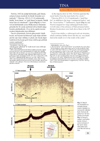
Fig. 2: Mendi-
rek üzerinden eş
zamanlı alınan
sismik (üstteki) ve
batimetrik (alttaki)
kesit. Kırmızı ile
gösterilen hat üze-
rinden alınmıştır.
Fig. 2: Seismic
(upper) and bathy-
metric (lower)
cross-sections of
the mole taken
simultaneously
over the red survey
line.
55