
Page 32 - TINA Dergi Sayi 08
P. 32
TINA
Denizcilik Arkeolojisi Dergisi
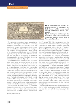
Fig. 4: Sennacherib (MÖ 704-681) Dö-
nemi’ne tarihlenen bir Asur kabartması.
Dicle üzerinde kelekle taşınan mimari
parçalar görülmektedir. (Layard, 1853,
plate 13)
Fig. 4: An Assyrian relief dating to the
Sennacherib Period (704-681 BC) shows
architectural elements carried upon a
kelek on the Tigris River.
The settlement is located on a natural peninsula at the the 10 century Tell Fafan was an active port city
th
10
confluence of the Tigris and Botan Rivers, overlooking for transfer of goods from Erzen, Bitlis, and Ermeniye
both rivers near Çattepe (Tilli / Tili / Til) Village. The further north to Mosul on the Tigris River, however it
waterflow in this area is quite suitable for river trans- failed to maintain this activity after the 11 century.
th
port since it is located at the confluence to two big riv- Due to bandit groups increasing in the region in par-
ers. According to Arab geographers, Çattepe was one allel with Marwanid dominance after the 11 century,
th
of the major commercial cities and ports of Al-Jazirah, this route became very dangerous for large trade car-
especially through the 10 century. A harbor structure avans, which led to merchants abandoning this inse-
th
that was mentioned in the medieval documents has cure route. As a result, Tell Fafan lost its importance
been unearthed on the banks of the Tigris River to the as a port city and became a smaller village. After the
southwest of the settlement (Fig. 6-7). Artuqids became a dominant force in the region and
This harbor structure was initially built for a fresh- Hasankeyf became a capital city, the land route run-
water source in the late Roman imperial period. The ning to the south through Midyat and Nusaybin be-
structure seems to have been built as a cistern to store came an important transportation link. As a result,
potable freshwater. Since the Tigris River flowed far river transport lost its preeminent position, and Çat-
to the west, the water would have been transferred to tepe/Tell Fafan was completely abandoned. Absence
the fortress through channels over a distance. Later of any reference to Tell Fafan in the records from the
on, probably when the Tigris River changed its course 12 and 13 century indicates that the settlement and
th
th
and began to flow by the fortress as a result of tectonic the harbor had already lost significance during this
movement, this structure, which had been used as a period. The harbor structure, which became obsolete
cistern, was turned into a port with minor modifica- after abandonment of Tell Fafan, remained under the
tions. The bollards inside the walls (Fig. 8) provide alluvial deposits brought down by the Tigris River
evidence of this change. In addition, round holes with and became completely unusable over time. After this
a diameter of 8 to 10 cm on the walls of the harbor period, Hasankeyf gained strategic importance in the
structure indicate that keleks or other transportation region, becoming an important city for river transport
vessels were attached to wooden poles pegged here. leading to Mosul.
We believe that the Islamic city of Tell Fafan was Transportation of humans and merchandise on the
built on this mound after the late Roman imperial pe- river by keleks has been described in detail by con-
riod, due to the geopolitical and commercial impor- temporary travelers and officials journeying to the
tance of the site. According to written sources, during region.
10 ÇEVİK, 336, footnote 228.
30