
Page 156 - TINA Dergi Sayi 10
P. 156
TINA
Denizcilik Arkeolojisi Dergisi
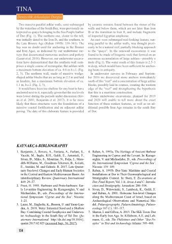
Two massive parallel ashlar walls, semi-submerged by ceramic remains found between the stones of the
by the waterline of the South Bay, were previously in- walls and below them, which are not later than Iron
terpreted as quays belonging to the Sea People harbor Ib or the transition to Iron II, and include fragments
of Dor (Fig. 1). The northern one, closer to the tell, of imported Egyptian amphorae.
was initially dated to the Iron Ib, and the southern, to An east–west submerged reef-looking feature, run-
the Late Bronze Age (Raban 1995b: 339–341). The ning parallel to the ashlar walls, was thought previ-
bay was no doubt used for anchoring in the Bronze ously to be a natural reef, partially blocking approach
and Iron Ages, as indicated by our underwater sur- to the “quays”. In the renewed excavations it was
veys that documented numerous anchors and pottery found to be made of biogenic rock that formed on an
(Lazar et al. 2018). However, our underwater excava- enormous accumulation of large ashlars—possibly a
tions have demonstrated that the southern wall com- mole (Fig.1). The water south of this feature is 2.5–3
prises a single course of rectangular, flat ashlars with m deep, which would have been sufficient for anchor-
a maximum bottom elevation of ca. 0.6 m b.s.l. (Fig. ing boats in antiquity.
2, 3). The northern wall, made of massive wedge- In underwater surveys in February and Septem-
shaped ashlar blocks that are as long as 2.5 m and laid ber 2016 we discovered stone anchors immediately
as headers, has a maximum bottom elevation of ca. south of this “reef” and a concentration of large ashlar
1.1 m, b.s.l. (Fig. 2, 3). blocks, possibly laid in courses, creating the western
It would have been too shallow for any boat to have edge of the “reef” and strengthening the hypothesis
anchored next to it, especially given that the sea levels that this is a maritime construction.
were lower during the periods under discussion (Siv- Future underwater excavations, planned for 2019
an et al. 2001; Benjamin et al. 2017). It is far more and 2020 will enable to tell more about the exact
likely that these structures were the foundations of a function of these sunken features, as well as on ad-
massive coastal fortification and an adjacent ashlar ditional possible Iron Age remains in the south Bay
paving. The date of this elaborate feature is provided of Dor.
KAYNAKÇA-BIBLIOGRAPHY
1. Benjamin, J., Rovere, A., Fontana, A., Furlani, S., 4. Raban, A. 1995a. The Heritage of Ancient Harbour
Vacchi, M., Inglis, R.H., Galili, E., Antonioli, F., Engineering in Cyprus and the Levant. In: Karage-
Sivan, D., Miko, S., Mourtzas, N., Felja, I., Mere- orghis, V. and Michaelides, D., eds. Proceedings of
dith-Williams, M., Goodman-Tchernov, B., Kolaiti, the International Symposium ‘Cyprus and the Sea’.
E., Anzidei, M. and Gehrels. R. 2017. Late Quater- Nicosia: 139–189.
nary Sea-level Changes and Early Human Societies 5. Raban, A. 1995b. Dor-Yam: Maritime and Coastal
in the Central and Eastern Mediterranean Basin: An Installations at Dor in Their Geomorphological and
interdisciplinary Review. Quaternary International Stratigraphic Context. In: Stern, E. Excavations at
449: 29–57. Dor, Final Report, Vol. 1 A: Areas A and C: Introdu-
2. Frost, H. 1995. Harbours and Proto-harbours: Ear- ction and Stratigraphy. Jerusalem: 286–354.
ly Levantine Engineering. In: Karageorghis, V. and 6. Sivan, D., Wdowinski, S., Lambeck, K., Galili, E.
Michaelides, D., eds. Proceedings of the Interna- and Raban, A. 2001. Holocene Sea-level Changes
tional Symposium ‘Cyprus and the Sea’. Nicosia: along the Mediterranean Coast of Israel, based on
1–21. Archaeological Observations and Numerical Mo-
3. Lazar, M., Engholtz, K., Basson, U. and Yasur-Lan- del. Palaeogeography, Palaeoclimatology, Palaeo-
dau, A. 2018. Water Saturated Sand and a Shallow ecology 167 (1): 101–117.
Bay: Combining Coastal Geophysics and Underwa- 7. Sharon, I. and Gilboa, A. 2013. The SKL Town: Dor
ter Archaeology in the South Bay of Tel Dor. Qu- in the Early Iron Age. In: Killebrew, A.E. and Leh-
aternary International http://dx.doi.org/10.1016/j. mann, G., eds. The Philistines and Other “Sea Pe-
quaint.2017.02.025 (accessed Sept. 30, 2017). oples” in Text and Archaeology Atlanta: 393–468.
154