
Page 59 - TINA Dergi Sayi 7
P. 59
TINA TINA
Denizcilik Arkeolojisi Dergisi Maritime Archaeology Periodical
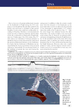
Due to discovery of ancient architectural elements enlargement. In addition to that, the seismic records
on the breakwater of Ereğli during the 2015 cam- taken from the mid-point of the breakwater (at the
paign, it was thought that the part that reached to the point where these records are taken, the deepest point
present was renovated or extended in later period. of the breakwater is approximately 4,5-5 meters)
Hoepfner’s book is also contributive at this point. Ac- shows the profile of the breakwater (Fig. 7) . Only
11
cording to Hoepfner, Herakleia is an important port the sonar images were obtained because the other
on the sea route to Trapezus (Trabzon), and the name breakwater to the south of Ereğli is very close to the
of the city is referred to as Puntarachia (Pontaherak- water surface (Fig. 8). However, we noticed a differ-
leia) on a Catalan map of the 13th century (Fig. 6) . ent feature distinguishing it from the Ereğli breakwa-
10
This name is an indication of Genoese presence in ter. To the immediate north of the main 140 m long
Herakleia. It gives a better idea about the condition of protrusion, there is another, but shorter breakwater
the ancient architectural elements on the breakwater. protrusion (Fig. 8). It has a different architecture than
It is likely that the breakwater of Herakleia was en- the Ereğli breakwater. However, since only a small
larged during the Genoese period due to its increased portion is visible, and the majority remains under a
importance, and probably the architectural blocks of modern road fill, it is not possible to make any com-
the buildings in ancient city were used during this ment at least for the moment.
10 HOEPFNER 1966, 5; “Byzance se maintient encore sur le littoral, jusqu’à l’embouchure du Sangarios; le centre de ses possessions,
après la perte de la Paphlagonie, est à Héraclée du Pont (Bender Eregli), sue les Grecs appellent Pontoherakleia et les ltaliens Punt-
arachia.” Please see BRATIANU 1929, 114.
11 This breakwater was drawn in the plan by Hoepfner as it is. Hoepfner reports that this breakwater is the southern one of the two
breakwater arches that make up the pit of the ancient Ereğli harbor, and it lost its original form due to earthquakes and waves over
time. An analysis of the stones forming the breakwater supports Hoepfner’s argument. Please see HOEPFNER 1966, 11-14, plan 1a.
Fig. 7: Ereğli
antik mendire-
ğinin Sub-bot-
tom profiler
ve yanal ta-
ramalı sonar
görüntüsü.
Fig. 7:
Sub-bottom
profiler and
side-scan so-
nar view of
the ancient
breakwater of
Ereğli.
56 57