
Page 73 - TINA Dergi Sayi 11
P. 73
TINA
Maritime Archaeology Periodical
ABSTRACT harbor cities along the shores of Western Anatolia.
The ancient city of Patara, now lying within the The alluvials that have been carried for thousands of
borders of the Antalya Province, was an important years have filled the Esen Plain on one side, trans-
2
harbour city during the anceint period, and also forming it into soil to a great extent . On the other
served as the capital city of the Lycian League. The side, the finer sands carried towards the sea have
harbor around which the city was built is a wetland formed a set of about 12 km long and hundreds of
now. The wetland and its environs, which makes it meters thick between the plain and the sea by winds
difficult to conduct a scientific research in the area, and currents. The front part of the Patara harbor bay
have a very rich architectural texture. It is also like has a thickness of approximately 600 m. The sands,
a unique repository, hiding the traces of paleoenvi- which close the entrance to the ancient bay just like
ronmental changes that have occurred over the past a dam, also lead the level of water in the bay to rise
thousands of years. In proportion to this difficulty, up to one meter above the sea level from time to
there are only a few scientific studies that have been time. Both this situation and the overall sea level rise
conducted so far in this region. Nevertheless, it is since the ancient period have resulted in a wetland
possible to put it into a persepective based on pre-
vious studies and observations. Having a very im- moving through the narrow strait to the north, and
portant data potential, the Patara harbor bay will be encroaching until the modern village of Gelemiş.
illuminated only by combined efforts of many disci- Thus, there occured a marsh area of approximately
plines such as geoarchaeology and geophysics. 1500 m long and 400 m wide, which is covered with
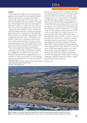
The ancient harbor bay of Patara is a wetland sur- reeds. On the north-south line, there are two pear-
rounded by reeds, which is now disconnected with shaped ponds, where the northern one measures
the sea (Fig. 1) . The Xanthos river (Eşen Çayı/ approximately 200x130 m, and the southern one
1
Kocaçay), spilling into the sea approximately 5 km 190x105 m in dimensions. With a depth of 5 m, their
northwest of Patara is responsible for this landscape, underwater visibility is about 50 cm due to organic
which we are also used to see in many other ancient materials in the form of particles .
3
1 ÖNER 2009; IŞIK – KOÇAK 2014; KOÇAK 2016a;
ÖNER 2009; IŞIK – KOÇAK 2014; KOÇAK 2016a; DÜNDAR – KOÇAK in print.
1
Only a few places still have wetland lakes.
DÜNDAR – KOÇAK in print. 2 3 ÖZDAŞ – KIZILDAĞ 2014.
Only a few places still have wetland lakes.
2
3 ÖZDAŞ – KIZILDAĞ 2014.
Fig. 1: Bugün bir bataklığa dönüşmüş haldeki Patara liman koyu, güneyden görünüş (Patara Kazı Arşivi)
Fig. 1: A view of the Patara Harbor Bay from South, which is now a wetland (Patara Excavations Archive)
71