
Page 65 - TINA Dergi Sayi 11
P. 65
TINA
Maritime Archaeology Periodical
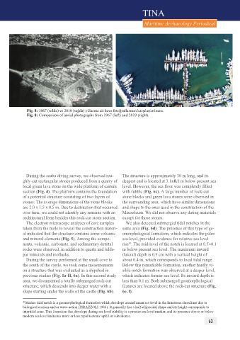
Fig. 8: 1967 (solda) ve 2019 (sağda) yıllarına ait hava fotoğraflarının karşılaştırılması.
Fig. 8: Comparison of aerial photographs from 1967 (left) and 2019 (right).
During the scuba diving survey, we observed rou- The structure is approximately 30 m long, and its
ghly-cut rectangular stones produced from a quarry of deepest end is located at 3.1±0.1 m below present sea
local green lava stone on the wide platform of eastern level. However, the sea floor was completely filled
section (Fig. 4). The platform contains the foundation with rubble (Fig. 6c). A large number of rock-cut
of a potential structure consisting of two layers of stone blocks and green lava stones were observed in
stones. The average dimensions of the stone blocks the surrounding area, which have similar dimensions
are 2.0 x 1.5 x 0.5 m. Due to destruction that occurred and shape to the ones used in the construction of the
over time, we could not identify any remains with an Mausoleum. We did not observe any dating materials
architectural form besides this rock-cut stone section. except for those stones.
The electron microscope analyses of core samples We also detected submerged tidal notches in the
taken from the mole to reveal the construction materi- same area (Fig. 6d). The presence of this type of ge-
al indicated that the structure contains some volcanic omorphological formation, which indicates the paleo
and mineral elements (Fig. 5). Among the compo- sea level, provided evidence for relative sea level
30
nents, volcanic, carbonate, and sedimentary detrital rise . The mid-level of the notch is located at 0.5±0.1
rocks were observed, in addition to quartz and felds- m below present sea level. The maximum inward
par minerals and mollusks. (lateral) depth is 0.3 cm with a vertical height of
During the survey performed at the small cove to about 0.4 m, which corresponds to local tidal range.
the south of the castle, we took some measurements Below this remarkable formation, another hardly vi-
on a structure that was evaluated as a shipshed in sible notch formation was observed at a deeper level,
previous studies (Fig. 1a-II, 6a). In this second study which indicates former sea level. Its inward depth is
area, we documented a totally submerged rock-cut less than 0.1 m. Both submerged geomorphological
structure, which descends into deeper water with a features are located above the rock-cut structure (Fig.
slope starting under the walls of the castle (Fig. 6b). 6e, f).
30 Marine tidal notch is a geomorphological formation which develops around mean sea level in the limestone shorelines due to
biological erosion and/or wave action (PIRAZZOLI 1986). It generally has a half-ellipsoidal shape and its height corresponds to
intertidal zone. This formation that develops during sea level stability is a precise sea level marker, and its presence above or below
modern sea level indicates more or less rapid tectonic uplift or subsidence.
63