
Page 67 - TINA Dergi Sayi 10
P. 67
TINA
Maritime Archaeology Periodical
teŞeKKÜr ACKnOwLeDGmentS
Aşağıda adı geçenlere araştırmaya yaptıkları We wish to thank the following for their financial support
finansal destek için teşekkür ederiz: COST Action of the research described here: the EU through COST
TD0902 SpLASHCOS kanalıyla AB, National Action TD0902 SPLASHCOS, the National Geographic
Geographic Araştırma Fonu, CARE Arkeoloji Research Foundation, CARE Archaeological Founda-
Vakfı, MAFCAF Vakfı, Dan David Vakfı ve tion, MAFCAF Foundation, the Dan David Foundation
Honor Frost Vakfı. Israil Eski Eserler Kurumu, Is- and the Honor Frost Foundation. The Israel Antiquities
rail prehistorik Derneği ve Hayfa Üniversitesi’ne Authority, the Israel Prehistoric Society and Haifa Uni-
sualtı kazılarındaki finansal ve yönetsel destekleri versity are acknowledged for their financial and admin-
için teşekkür ederiz. H. Rosenstein ve Fantasea’ya istrative support of the underwater excavations. We
fotoğraf ekipmanlarını sağlamalarından ötürü; su- wish to express our appreciation to: H. Rosenstein and
altı kazılarında yer alan gönüllü dalgıçlar ve arke- Fantasea who provided photographic equipment; the
ologlara; buluntuların üzerindeki çalışmalarıyla volunteer divers and archaeologists who participated in
katkı yapan birçok araştırmacıya; bazı çizimleri the underwater excavations; to the many researchers who
yapan S. Ben-Yehuda ve B. Galili’ye; bazı sualtı contributed to the study of the finds; S. Ben-Yehuda and
fotoğraflarını çeken J. Galili ve I. Grinberg’e; M. B. Galili for producing some of the drawings; J. Galili
Rasovsky’ye (organik malzemenin işlenmesi); and I. Grinberg for taking some of the underwater photo-
Weizmann Radyokarbon Tarihleme Enstitüsünden graphs; M. Rasovsky (treatment of organic material); D.
D. Segal, I. Carmi ve E. Boaretto’ya; bazı metin- Segal, I. Carmi and E. Boaretto of the Weizmann Insti-
leri düzelten ve yorumlarıyla katkıda bulunan tute for radiocarbon dating; Geoff Bailey for his remarks
Geoff Bailey’ye ve metin üzerine aldığı notları and for editing some of the text and R. Galili for her
paylaşan R. Galili’ye teşekkürlerimizi bildirmek notes on the text.
isteriz.
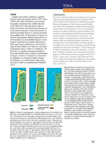
Fig. 26: Kuzey Carmel kıyısının kıyısal kon-
figürasyonunun yeniden inşa edildiği bir mo-
del: A) Çanak Çömleksiz Neolitik C (ppNC)
(günümüzden yakl. 9000 yıl önce) deniz sevi-
yesi yüksekliği yaklaşık bugünkü deniz sevi-
yesinin 15 m altındaydı, Carmel Burnu batı
ve doğu saçaklarında iki kurkar sırtıyla çevrili
kayalık bir levhaydı; Atlit ve Haifa arasındaki
kıyı kayalıktı, kurkar sırtının rüzgar tarafında
kıyıya paralel kara uzantıları oluştıran lagün
uzantıları bulunmaktaydı; Atlit yarımadasının
güney kıyısı kumluktu; B) Çanak Çömlekli
Neolitik sırasında (günümüzden yaklaşık
8000 yıl önce) deniz seviyesi bugünkü se-
viyesinin yaklaşık 10 m altındaydı, Carmel
burnu levhasının bir yanı suyla kaplıydı, batısı
bir ada uzantısıydı, güney kıyısı kumluydu
ve kıyı açıklarında birkaç küçük ada bulu-
nuyordu; Atlit’in güney kıyısı kayalıktı. C)
Günümüzde kuzey Carmel kıyısı. Kayalık
Carmel burnu levhası tamamen suyla kaplıy-
dı, buradaki kıyı kayalıktır dalga aşındırma
düzlükleri vardır; güneyde kıyı kumlu ve
Fig. 26: A model reconstructing the coastal configuration of the northern Car- düzdür; Atlit’den güneye kıyı girintili çıkıntılı
mel coast: A) During the PPNC (ca. 9000 BP) the sea level was ca 15 m bsl, ve kayalıktır, küçük koylar vardır. Atlit-Yam
The Carmel nose was a rocky plate, surrounded by two kurkar ridges on its yerleşmesi ve Çanak Çömlekli Neolitik yer-
west and east fringes; the coast between Atlit and Haifa was rocky, with elon- leşmeler su altındadır.
gated lagoons on the lee side of the kurkar ridge that created elongated land
tongues parallel to the coast; the coast south of Atlit peninsula was sandy; B)
During the Pottery Neolithic (ca. 8000 BP) the sea level was ca. 10 m bsl,
The Carmel nose plate was partly flooded, west of it was an elongated island,
the coast to the south was sandy with several small islands off shore; the co-
ast south of Atlit was rocky. C) The northern Carmel coast today. The rocky
Carmel nose plate is totally flooded, the coast there is rocky with abrasion
platforms; to the south the coast is sandy and straight; from Atlit to the south
the coast is indented and rocky, with small bays. The Atlit-Yam site and the
Pottery Neolithic sites are submerged.
65