
Page 111 - TINA Dergi Sayi 08
P. 111
TINA
TINA NEWS
Maritime Archaeology Periodical
Söz konusu batık alanları ancak bu tip
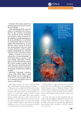
yüksek hassasiyetteki cihazlar ile görün- Osmanlı Dönemi’ne
tülenebilmektedir. ait batığın metal
Antik çağlardan günümüze kadar kul- aksamları. (Fotoğraf:
lanılan en önemli deniz ticaret rotaların- Harun Özdaş)
dan biri olan Çanakkale kıyılarındaki Metal parts of the
Truva açıklarında yapılan araştırmada, shipwreck from Otto-
aynı zamanda I. Dünya Savaşı’nda bat- man period. (photo by
mış gemilerin de büyük çoğunluğu akus- Harun Özdaş)
tik olarak görüntülenmiş ve tam konum-
ları belirlenmiştir. Marmara Denizi’nde
yapılan sonar taramasında ise, 45 metre
derinlikte mermer taşıyan bir batık ile
çok sayıda potansiyel batık alanı tespit
edilmiştir. Kötü hava şartları nedeniyle
program kapsamındaki bazı bölgelerin
incelemesi ise 2018 takvimine alınmıştır.
Bodrum Yalıkavak kıyılarında ger-
çekleştirilen sonar haritalamasında, 50
ila 90 metre arasında yaklaşık 15 adet
sonar kontağı saptanmıştır. Önümüz-
deki yıl projemiz kapsamında alınacak
ROV cihazı (uzaktan kumanda edilen
sualtı robotu) ile, sportif dalış derinlik-
lerinin ötesindeki yukarıda sözü edilen
anomalilerin görüntülenmesi mümkün
olacaktır.
Enstitümüz bünyesinde oluşturulan
Türkiye Sualtı Kültür Mirası Coğrafi
Bilgi Sistemine, her yıl olduğu gibi, bu
yıl da önemli veriler eklenerek ülkemi-
zin ve insanlığın ortak hafızası olan veri
tabanımız geliştirilmiştir.
Such shipwreck sites can only be detected using Approximately 15 sonar contacts between 50 and 90
high-resolution professional systems such as this. meters have been identified in the sonar mapping per-
During our survey conducted off Troy on the Çanak- formed along the coast of Yalıkavak, Bodrum. These
kale coast, which lies near one of the most important contacts that are located beyond sportive diving depths
maritime trade routes used from ancient times to the will be imaged by ROV (remotely operated vehicle),
present, we acoustically imaged a number of ships which will be obtained in the next year as part of our
from World War I and mapped their exact locations. project.
During a similar sonar survey carried out in the Sea of As in the past years, in 2018 significant data was
Marmara, we found a shipwreck at a depth of 45 me- added to the Geographical Information System of Un-
ters which contained marble, as well as a large number derwater Cultural Heritage of Turkey, created by our
of other potential shipwreck sites. Due to the weather Institute. Recent data has expanded the cultural heri-
conditions, survey of some of the regions covered by tage database, which represents a collective memory
our schedule had to be postponed until 2018. for our country.
109