
Page 115 - TINA Dergi Sayi 08
P. 115
TINA
TINA NEWS
Maritime Archaeology Periodical
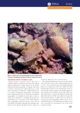
Kekova Adası sualtı araştırmalarında bulunan amphoralar.
Amphoras found during Kekova Island underwater survey.
unDerwAter SurVeYS İn KeKOVA ISLAnD the archaic shipwreck area at Tersane Koyu.
Kekova Island is located 4 km to the west of The northern settlement area lies on the slope of the
Andriake Harbor, and 4 km to the south of the ancient island that faces north, with a depth ranging from 15
Simena settlement at Üçağız Mevkii of the Demre to 32 m. The second location is the Karaöz Mevkii
District in the present province of Antalya. The island lying to the southeastern end of the island. The third
is about 7.5 km long, the widest part being 1.8 km location, Eğri Liman is in the southern part of the is-
long. Extending in northeast to southwest direction, land, and the fourth location is an archaic shipwreck
it is mainly occupied by steep slopes. The highest area located in the southwest of the island that con-
peak is approximately 180 m. While its mountainous tains shipwrecks of Cypriot and Egyptian origin. The
topography is not suitable for cultivation, it also re- underwater surveys which were carried out in parallel
stricts urban settlement. It underlies the presence of with the land surveys included dives for detection,
settlements only in two parts of the island. We have observation and photography studies in the above
been conducting underwater surveys since 2007 in mentioned locations. The main purpose of the surveys
four different locations, including the northern settle- was to elucidate the contemporary role of the island
ment area, the Karaöz Mevkii, the Eğri Liman, and in maritime trade.
113