
Page 53 - TINA Dergi Sayi 7
P. 53
TINA
TINA TINA NEWS
Denizcilik Arkeolojisi Dergisi Maritime Archaeology Periodical
SUMMaRY Sites and Shipwrecks on the Black Sea Coastline of
The 2016 campaign of the archaeological underwa- Bithynia”, which was initiated in 2015 was conducted
ter survey carried out since 2015, by the Archaeology in the coastline from Kovla Mevkii in the southwest and
Department of the Düzce University took place in the Çavuşağzı Bay in the northeast, taking the Karadeniz
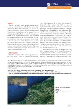
shores of Zonguldak Province, on the western coast of Ereğli District of Zonguldak Province at the center (Fig.
1
Black Sea, within the borders of the ancient Bithynia. 1) . The 2016 campaign focused on scanning for ship-
Using geophysical methods, we carried out imaging ac- wrecks using archaeo-geophysical methods and imaging
tivities on the ancient breakwater, that was discovered of the harbor structures. The survey was performed by
and documented during the 2015 campaign, by sonar Prof. Muhammet Duman and Research Assistant Tarık
and sub-bottom systems at the center and south of Ereğ- İlhan of the Institute of Marine Science and Technolo-
li. We also surveyed a 32-km shoreline up to Alaplı in gy of the Dokuz Eylül University. The vessel ATA 5 of
the south and Balı in the north using sonar and sub-bot- the Deep Sea Diving Center was used during the survey.
tom systems. In addition to the a.m. locations, we doc- This phase of the survey included use of a “sidescan so-
umented a potential site of a Late Byzantine shipwreck nar system” and a “sub-bottom profiler” to explore what
defined by two Y-shaped anchors in an area called Kova lies under the seabed (Fig. 2).
Mevkii to the southwest of Ereğli. Based on the survey results obtained in 2015, the
2
2016 campaign focused on the ancient breakwater of
1. IntrODuCtIOn Ereğli (Herakleia Pontike/Heracleia Pontica) and the
The 2016 campaign of the archaeological underwa- remains of a 140 m long ancient breakwater lying to
ter survey called “Survey of Potential Ancient Ports, the east of this breakwater between Ereğli and Alaplı.
1 The official representative of the 2016 campaign which was carried out with the permission of the General Directorate of Cultural
Heritage and Museums, Ministry of Culture and Tourism was Serkan Gedük of the İstanbul Topkapı Museum. The research was finan-
cially supported by the Scientific Research Projects Coordination Unit of Düzce University (BAP Project No: 2015.05.07.377). The
study participants were Asst. Prof. Ahmet Bilir, Prof. Dr. Muhammet Duman, Res. Asst. Tarık İlhan, Diver Volkan Demircioğlu and
Rümeysa Keser, a 3rd grade student of Archaeology, Düzce University.
2 OKAN et al. 2015.
*Asst. Prof. Emre OKAN, Underwater Research and Application Center, Düzce University.
**Asst. Prof. Ahmet BİLİR, Archaeology Department, Faculty of Science and Letters, Düzce University.
***Prof. Dr. Muhammet DUMAN, Marine Geology & Geophysics, Institute of Marine Science and Technology, Dokuz Eylül University.
Fig. 1: 2016 yılı çalışma
sahası.
Fig. 1: The survey area in
2016.
50 51