
Page 141 - TINA Dergi Sayi 08
P. 141
TINA
Maritime Archaeology Periodical
Considering that the ancient records of the island are no sent to exile and once the Armonians Monastery was lo-
later than the 10th century, it is probable that Vordonisi cated. In order to prove this from an archaeological point
inundated during this period. However, an explicit men- of view, we need to identify the architectural remains of
tion of Vordonis in a map of 1770 (Fig. 2) prepared by J. the monastery on the island. Therefore, we wanted to
L. Cowley raises doubts about this probability. While the clarify the claims about the presence of patriarch pho-
earthquake and tsunami that occured on May 22, 1766 tios’ monastery and that the island on which it was built
led to damage in the Mudanya Bay and the Bosphorus, all had been devastated by an earthquake. We spend efforts
this happened before the map of 1770 was drawn. After to obtain clues about the history of the island. We also
this date, the first major earthquake that caused tsunami aim to register quickly it if remains of such a building are
had occurred on July 10, 1894 . However, this tsunami found on the island.
12
did not cause much changes on the Anatolian coastline . Our survey dives focused on four different points of
13
It is also better not to rule out that Vordonisi may have the study area where cliffs rising from the sea are located
been specifically indicated in the above mentioned map because we believe that remains should be located
to warn sailors against dangerous rocks. in shallows. In addition, when viewed from a satel-
In the mean time, these rocks are also referred to by lite photograph (Fig. 3), it was observed that most
the sailors as the Monastery Rocks. It is clear that the of the settlements in the princes Islands looked
Adalar (Islands) district of Istanbul, also called the princ- northward, that is, the Anatolian side of Istan-
es Islands, served as a religious and political exile center bul, and it was estimated that the possible build-
during the Byzantine period. For this reason, this sunken ing remains could be on the north facing side of the
land may be the island where the patriarch photios was sunken island.
12 Especially in Heybeliada, it was recorded that sea water broke at the shore violently after ebbing approximately 15m, causing the
boats in the bay to sink in the south of the island (ALTINOK et al. 2001, 531).
13 ALTINOK et al. 2001, 531.
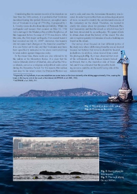
Fig. 4: Kayalıklar üzerindeki çakar.
Fig. 4: Beacon on the rock.
Fig. 5: Deniz yüzeyin-
deki kayalık.
Fig. 5: The rock above
the sea surface.
139