
Page 46 - TINA Dergi Sayi 11
P. 46
TINA
Denizcilik Arkeolojisi Dergisi
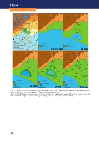
Fig. 19: Tarsus ovası ve Gözlükule Höyüğü çevresindeki sondaj yerleri, paleocoğrafya haritası (sol üstte) ile ovanın son
7000 yıllık döneme ait gelişme haritaları (Öner vd, 2003a; 2003b; 2005a).
Fig. 19: Core drilling sites and paleogeographical map of the Tarsus plain and vicinity of Gözlükule Mound (upper left)
and evolutionary stages of the plain for the past 7000 years (Öner et al, 2003a; 2003b; 2005a).
44